
Shaking (Amplification)
Humans cannot yet predict the occurrence(s) of earthquakes. When expected earthquake motion is accurately predicted, engineering design to accommodate the loads and motions is possible (not all buildings collapse; building codes can be successful). Therefore, the challenge is to predict the motions.
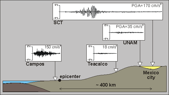
Subsurface ground conditions will alter earthquake shaking, known as earthquakes site effects. Typically softer sediments will increase or amplify earthquake motions. Figure 1 shows earthquake shaking (waveforms) recorded at four locations from the 1985 magnitude (M) 8.0 Mexico City earthquake. Earthquake shaking is high near the epicenter and decreases with distance away (attenuation). But shaking is increased in amplitude, duration, and lower frequencies (longer period) due to soft, thick lake bed deposits in Mexico City.
Earthquake recordings of the 1985 M 8.0 Mexico earthquake
(Image source: https://www.wikiwand.com/en/Seismic_site_effects)
Data Required
Many geodatasets are required for shaking (amplification) hazard mapping. These include: subsurface geology from boreholes including sediment type and thickness, geophysical measurements (shear wave velocity, density), and geotechnical measurements (soil strength, dynamic behaviour).
Methodology
- Assemble and consistently analyze recordings of earthquake shaking at sites with seismic instrumentation, e.g., British Columbia Smart Infrastructure Monitoring System.
- Assess seismic site response using empirical earthquake & passive seismic (microtremor) recordings.
- Evaluation of site characterization using remote sensing techniques including topographic slope, terrain classes, or other combinations.
- Perform 1D nonlinear site response analyses & study the application of 2D and 3D numerical simulations for more complex geometries (e.g. basin model).
- Selection of representative (design) site-specific input earthquake ground motions that are matched to a target spectrum compatible with the predicted seismic hazard (PSHA and DSHA).
Anticipated Products
- 3D geological & geophysical models (3D geodatabase)
- Maps of amplification due to site conditions for all shaking levels and periods
- Maps of site class (Vs30), site period (fpeak), etc.