
Landslide Hazard
A landslide is defined as movement of a mass of soil (earth or debris) or rock down a slope. Landslides can be triggered by either natural (e.g., earthquake shaking, heavy rain) or human-related causes (e.g., excavation of the slope’s base or toe). Landslide is a generic term for all kinds of mass movements, e.g., rockfall, slumps, slides, flows and creep. The type of mass movement depends on type of material, slope angle or steepness, and degree of water saturation. In Canada in the last 150 years, over 600 people have lost their lives to landslides, providing an average of four lives every year (Evans, 1999). The 1946 MS 7.3 central Vancouver Island earthquake (Figure 1) caused a number of landslides on Vancouver Island. The earthquake caused a promontory to slump into a bay south of Courtenay which generated a wave that overturned a small boat causing the fatality of a Vancouver man.
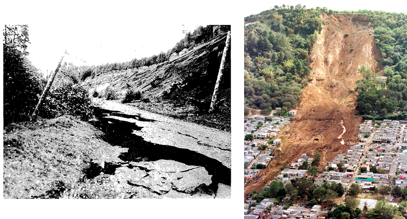 Figure 1. Left panel: Slumps in road fill in Kelsey Bay following the 1946 MS 7.3 Vancouver Island earthquake, making the Campbell River Highway impassable in several places (from Rogers 1980). Right panel: The Las Colinas debris flow triggered by the 2001 M 7.7 El Salvador earthquake which resulted in over 500 fatalities. (image from: http://landslides.usgs.gov).
Data Required
Seismic hazard mapping for landslides integrates topographic, geotechnical and seismological information to develop the earthquake-induced landslide potential. Using Newmark’s sliding block method, three sets of information are required:
- Block shape and height from topographic (elevation) information
- Subsurface geology and geotechnical measurements at many different locations
- Seismic hazard (input and surface ground motions)
Further, if available for the region, an inventory database of earthquake-induced or statically triggered landslides events is beneficial to develop or validate regional landslide potential mapping.
Methodology
- High-resolution topographic (digital elevation models, DEM) information with surficial geology mapping and groundwater measurements to develop landslide susceptibility hazard maps.
- Perform field observations of moderate and higher landslide susceptibility hazard in the region to inform static stability limits for different material types and slope steepness.
- Assemble inventory database of earthquake-induced landslides in the Pacific Northwest, documenting types of mass movements and their material.
- Develop two-dimensional (2D) models for representative slope hazards in the region based on regional information (see previous points) and geodatabase information.
- Evaluate potential for earthquake-triggered landslides using Newmark sliding block analysis (Figure 2) and empirical-based methods (e.g., Bray and Travasarou, 2007).
- Perform Newmark sliding block analyses to determine the static factor of safety and slope’s yield acceleration (ky) for representative slopes.
- Apply empirical-based method to evaluate slope’s performance (displacement) under earthquake loading; sliding displacement threshold is typically 15 cm.
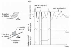
Figure 2. Newmark’s sliding block model including slope and sliding block representation subjected to earthquake loading and double integration of acceleration time-series (waveform) to compute permanent displacement (image from http://geotechsimulation.com/2018/02/16/seismic-coefficients-for-pseudostatic-slope-stability-analysis/)
Anticipated Products
- Landslide susceptibility map
- Probability of landslide potential (severity) map due to earthquake shaking
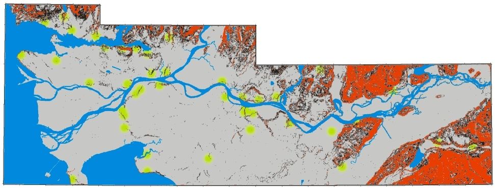
Figure 3. Image above shows a generalized interpretation of landslide susceptibility in the Greater Vancouver region. Areas with slope angles above 10° and 20° are shown in black and red, respectively. Locations of previous landslides are shown by green circles, from Eisbacher & Clague (1981). (image from: https://www.cgenarchive.org/vancouver-geomap.html).
References
- Bray, J. D., & Travasarou, T. (2007). Simplified procedure for estimating earthquake-induced deviatoric slope displacements. Journal of Geotechnical and Geoenvironmental Engineering, 133(4), 381-392.
- Eisbacher, G. H., & Clague, J. J. (1981). Urban landslides in the vicinity of Vancouver, British Columbia, with special reference to the December 1979 rainstorm. Canadian Geotechnical Journal, 18(2), 205-216.
- Evans, S. G. (1999). Landslide disasters in Canada 1840-1998. Geological Survey of Canada Open File.
- Newmark, N. M. (1965). Effects of earthquakes on dams and embankments. Geotechnique, 15(2), 139-160.
- Rogers, G. C. (1980). A documentation of soil failure during the British Columbia earthquake of 23 June, 1946. Canadian Geotechnical Journal, 17(1), 122-127.